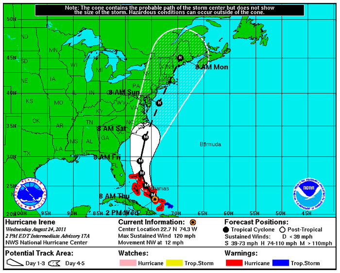
Just hauled Dorade at the dock at LMI as a precaution for Hurricane Irene. Hurricane Irene strengthened to a major Category 3 storm over the Bahamas with the East Coast in its sights. Irene is expected to get stronger over warm ocean waters and could become a Category 4 storm with winds of at least 131 mph (211 kph) by Thursday.
Irene is the first major hurricane along the East Coast in years. It’s been more than seven years since a major hurricane, considered a Category 3 with winds of at least 111 mph (179 kph), hit the East Coast. Hurricane Jeanne came ashore on Florida’s east coast in 2004. Officials in Rhode Island and Massachusetts are getting ready for Irene. Federal officials have warned Irene could cause flooding, power outages or worse all along the East Coast as far north as Maine, even if it stays offshore. The projected path has gradually shifted to the east, and Irene could make landfall anywhere from South Carolina to Massachusetts over the weekend. Craig Fugate, head of the Federal Emergency Management Agency, said people in New England should be ready for the storm.
Irene had already wrought destruction across the Caribbean, giving a glimpse of what the storm might bring to the Eastern Seaboard. In Puerto Rico, tens of thousands were without power, and one woman died after trying to cross a swollen river in her car. At least hundreds were displaced by flooding in the Dominican Republic, forced to take refuge in schools and churches. In Cuba, the storm sent waves crashing over a seawall in Baracoa, causing ankle-deep flooding in parts and damaging some sidewalks.
Forecasters warned it could get worse: The storm could strengthen in the next day or so. Irene could crawl up the coast Sunday toward the Northeast region, where people aren’t accustomed to such storms.
